National Tree Project
Multi-scale monitoring tools for managing Australian tree crops — industry meets innovation
Funding body
Rural Research and Development for Profit — Horticulture Innovation Australia Ltd
Overview and Proposed Project Outcomes
The latest high resolution satellite imaging systems, cloud-based computing, data discovery and computationally efficient analytics, on-ground robotics and an increasingly ‘connected’ producer base offer two key innovation pathways to improved production, auditing, biosecurity and disaster recovery for Australia’s tree crop industries.
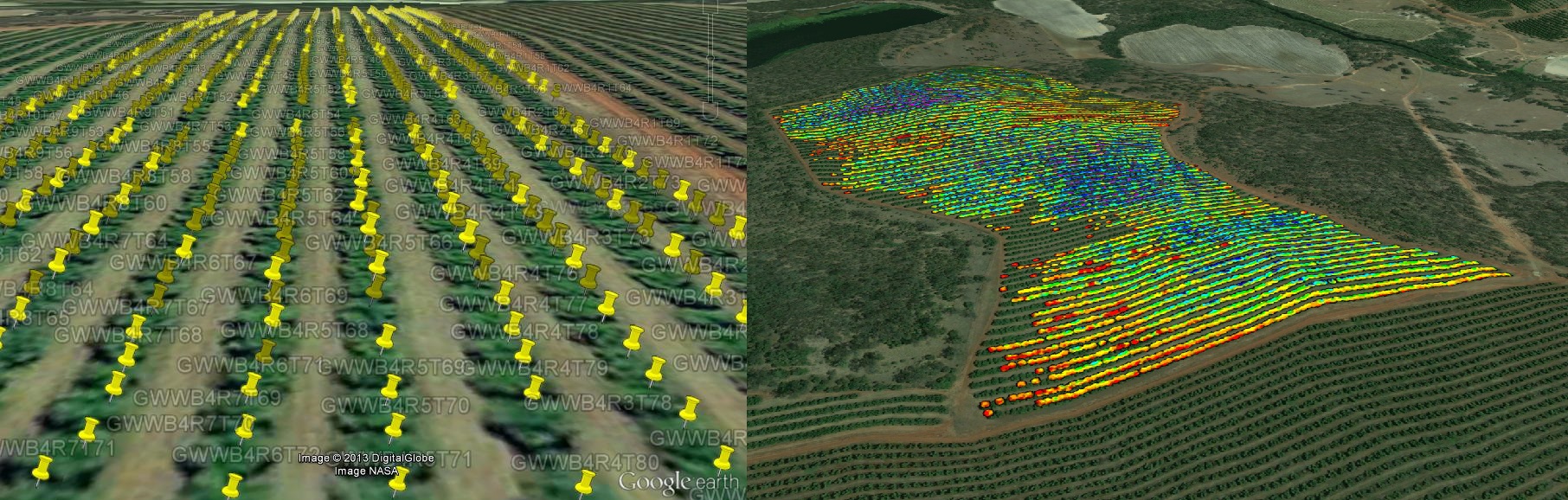
1. A national audit capability identifying the location, area and tree population of every commercial avocado, mango and macadamia orchard. The audit methodology will integrate novel satellite image analysis with existing industry and government crop databases, regional surveys and on-ground evaluations. A GIS database integrating a web delivery and data discovery platform will support grower auditing, seasonal and longer-term production forecasts, product traceability and facilitate productivity gains through improved understanding of the spatial and temporal distribution of cultivars, geographical regions, climate trends and production bases. The database will also support the biosecurity and post disaster monitoring at state and federal level.
2. A farm-level decision support tool utilising satellite image data streams and novel on-ground sensor systems, including machine vision and spectro-radiometric sensors, and robotic platforms for mapping fruit yield and quality, tree health and inflorescence counts. Data will assist yield forecasting and optimisation, harvest segregation based on quality and fruit size, tree health monitoring including early detection of pest and disease outbreaks, support product traceability (tree-to-plate), and reducing input costs through judicious management of water, fertiliser and pesticides, and genotype evaluation.
- Priority 1: Innovative satellite based remote sensing, on-ground robotics and non-destructive, ground based sensor systems will provide growers with an unprecedented understanding of the spatial and temporal variability of productivity and quality within their orchards. This information will support improved management and harvesting decisions, more informed application of inputs such as fertilisers, herbicides, fungicides and irrigation.
- Priority 2: An orchard based recording framework will improve information transfer from ‘tree to pack-house to market’, improving supply chain efficiencies and traceability. On ground robotic platforms and innovative field-based sensors will non-invasively assess fruit quality (e.g. dry matter levels) prior to harvesting, improving harvest management including the segregation of fruit based on differing metrics of edibility, quality and maturity.
- Priority 3: A national audit protocol, and the audit itself completed within this project, will facilitate multi-scale data integration; from the tree to orchard to national level. Industry partners have identified the accurate delineation of spatial and temporal production trends as critical to identifying strategic investment priorities and improving industry resilience in light of climate and allied resource (eg water) challenges, mitigating adverse environmental impacts, improving biosecurity including integrating with existing industry tools such as the MacSafe biosecurity plan, improving pest and disease control, and for assisting manage product chain resources through multi-scale production forecasts.
An orchard-level, tree-based data recording system allows growers to benchmark production and quality within and across growing seasons, and vastly improve product to market traceability. Tree-to-plate traceability will strengthen the global niche-producer image of Australian tree crop industry; a critical competitive edge when exporting to strictly controlled international markets. Orchard-level productivity and fruit quality maps derived from integrated sensor systems will support smarter applications of inputs, reducing environmental risks from farm runoff. - Priority 4: A secure web-accessible and discoverable GIS database will greatly support the consolidation of data from the individual tree to the industry level. As expressly identified by our industry partners, such information offers substantial benefit for short and long term industry planning, particularly for industry-wide marketing and coordination programs, for individual business management and for managing biosecurity threats.
Key Contact Person
Andrew Robson, UNE-PARG — 0417322137
Project Participants
University of New England
University of Sydney
University of Queensland
Central Queensland University
Joint Remote Sensing Research Program
Australian Mango Industry Association Ltd
Australian Macadamia Society
Avocado Australia Ltd
Simpson Farms
Department of Agriculture Fisheries and Forestry Queensland
AgTrix.
