Cotton PA
Contact David Lamb (dlamb@une.edu.au)
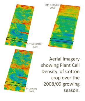
Precision agriculture (PA) involves a range of methodologies and technologies which aim to improve the precision of agricultural management in spatially-variable fields. Crop yield monitoring, high resolution aerial imagery and electromagnetic induction (EMI) soil sensing are three widely used techniques in PA. Yield maps provide an indication of the crop's response to a particular management regime in light of spatially-variable constraints. Aerial imagery provides timely and accurate information about crop conditions during the growing season and EMI indicates spatial variability in soil texture, salinity and or moisture content; the output of both tools is often inextricably linked to crop yield. Managers on a cotton farm in northern NSW found a bell curve relationship between yield and apparent electrical conductivity (ECa) where cotton yield is lowest in the extremes of ECa. Irrigation scheduling and nitrogen management are targeted at the majority soil class type which results in excessive irrigation on soils with high ECa as a result of water-logging and water limitations on soil with a low ECa. This research investigates the potential of using a combination of EMI sensing in conjunction with high resolution aerial imagery and differential fertilizer management to optimise the match between spatially-variable plant water demand and plant available water. Results so far suggest that ECa soil class maps as a basis of spatial variability is a useful method to interpret spatially variable water demand in cotton. Additionally the combined analysis of yield maps and high resolution aerial imagery indicates efficacy of soil class management as a function of yield and profit. Results also suggest that variable rate applications of in-season nitrogen can optimise cotton production on alternate soil classes when irrigating for the majority soil class.
(Images courtesy of Andrew Smart, PCT Australia)
