ARC Project Update: georeferencing of historic maps
Over the last month the project team has been georeferencing numerous historic maps and plans to create a spatial representation of changes to Port Arthur’s landscape during the convict period.
The Landscapes of Production and Punishment project brings together archaeological and historical data to recreate a landscape of convict labour. An integration of methods, including modern survey and remote sensing techniques, will help us understand how convict labour was used and experienced through a focus on the interaction between labour and the natural and built environment.
At Port Arthur, the form and function of places and spaces dramatically changed over forty-seven years between 1833 and 1877, posing a significant challenge to our presentation of spatial information. During that period, numerous settlement plans were produced, in addition to others depicting individual structures. These maps and plans are key to helping us understand what buildings may have looked like, what they were used for and how they related to one other. They are particularly important documents considering that many of Port Arthur’s buildings are no longer visible.
However, ranging in scale and accuracy, these maps and plans can be difficult to compare. To reconcile the disparities, GIS (Geographic Information Systems) is being employed to allow historic plans to be overlaid and scaled to modern features through a process of georeferencing.
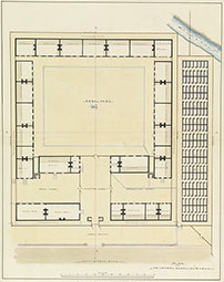 Over the last month the project team has been georeferencing numerous historic maps and plans to create a spatial representation of changes to Port Arthur’s landscape during the convict period. Using modern survey and LiDAR data, buildings are being mapped and coded and overlaid with important metadata about building usage and chronology.
Once this mapping is complete, we can link historical information to physical locations, populating the maps with information about places and types of work, produce flows and offence locations, thereby placing the convicts and their labour back within a spatial and temporal context. Through these methods, we may repopulate this historic landscape, reclaiming meaning for the many remnants and featureless spaces of Port Arthur and the Tasman Peninsula.
[Top image: Henry Laing's plan of the prisoners' barracks at Port Arthur (Tasmanian Archives and Heritage Office, with permission), overlaid on modern mapping using GIS.]
[Bottom image: Port Arthur's prisoners' barracks, 1836-56 (Henry Laing, ca.1836, 'Prisoners' barracks and cells', CON87/1/38 (Tasmanian Archives and Heritage Office, with permission)]
Contact:
Email:
