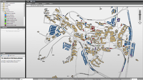
UNEMAP Campus
UNEMAP is a Web Delivered, Geospatial Campus Mapping Program developed and provided by UNE's Estate & Built Environment (EBE).
The Project Architecture is built around a Web Server, delivering up to date, UNE site information, via a Single Point of Truth Data Source.
A program of continual improvement will provide new Map Tools and Datasets to enhance the user experience and provide current information about your University.
Map Links
FMS UNEMAP
Click on the map above to launch - or this link if no image appears
Note - users must be logged in to the UNE network using their UNE account to gain access to the map.
Recommended Browsers
- Firefox
- Chrome
Things that you can search for within the map.
- AED's - (Defibrillators)
- Help Phones
- Buildings
- Paths
- Roads
- Parking bays (& their type)
- Aerial photo of Armidale campus including Tablelands Clinical School located on the hospital site.
Enquiries;
Email: Safety and Security
UNE Study Centres
Are identified on the UNE Campuses & Centres Maps
However, below are links showing the individual location of each of the UNE Study Centres using Google Maps street view.
Tamworth - 24 Fitzroy Street (Peel House)
Taree - Suite s 3 & 4 Manning Mall, 91 Manning Street
UNE Sydney (2 x locations)
- Google Maps Street View of 211 to 213 Church St Parramatta
- Google Maps Street view of 232 Church St Parramatta
Coonabarabran: Dalgarno Street, — TAFE campus (facing Tyre Auto Service Station)
Glen Innes: Glen Innes Severn Learning Centre, Grey Street
Gunnedah: Hunter Street, TAFE campus — up the ramp
Guyra: Armidale Regional Council (building at rear), cnr Bradley and Mackenzie Streets
Inverell: 11 Wood St, - TAFE campus — in library building
Moree: Frome Street, - TAFE campus — up the ramp next to library
Narrabri: Barwon Street, - TAFE campus — on verandah facing school
Tenterfield: High St, - TAFE campus - at rear of building


