Applied Agriculture Remote Sensing Centre
The Applied Agricultural Remote Sensing Centre (AARSC) at the University of New England (UNE) are a research team based across Armidale and Brisbane with a well-demonstrated and respected reputation for delivering strong applied remote sensing research outcomes to industry.
The AARSC currently leads and collaborates in remote sensing projects across more than a dozen agricultural and horticultural industries and have a proven record in developing national collaborative, multi-industry and multidisciplinary strategies in response to specific industry needs.
AARSC consists of two main divisions. The first predominately based on the Armidale campus focussing on remote sensing with the use of satellite imagery and model development in tree crops to produce data relating to yield forecasting, pest and disease, agronomic management and optimal planting and harvesting dates.
The second division being the Commodity Mapping team (based in Brisbane), currently working with industry bodies to deliver specific crop type maps for many agricultural industries across Australia and internationally. These maps provide participating industries with an intuitive framework for the collection, collation and interrogation of essential baseline data that underpins all decision making including more accurate measures of the current and annual change in production area and distribution, improved preparedness and response to biosecurity incursions and natural disaster events, traceability, labour and infrastructure needs.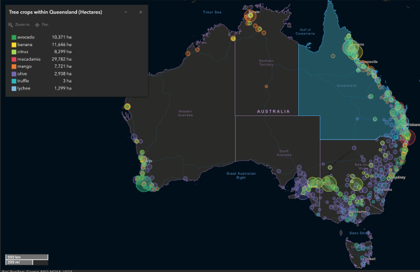
AARSC’s ability to respond to industry needs resulting in real world impact is evident in the delivery of the Australia Tree Crop Map (ATCM) and the Australian Protected Cropping Map.
Challenge
In 2014, a number of tree crop industry bodies expressed their need for more accurate spatial information that identified how big their area of production was and where all the commercial orchards were located.
Solution
The AARSC and collaborators responded to this need and delivered the first national map of participating tree crops (avocado, macadamia and mango) in 2017.
Whilst the immediate application of this data varied from better understanding industry extent (location and area) to annual change, it was also fundamental baseline data to underpin improved annual forward estimates of production, infrastructure planning, labour, transport and storage logistics, traceability and advocacy at all levels of government. Knowing the location of crops is also essential for biosecurity preparedness and natural disaster response and recovery.
The latest complete national map was delivered in 2022 and includes avocado, olive, mango, macadamia, citrus, banana and truffles. AARSC are maintaining the map with updates published twice-per-year for the majority of these tree crops and are now compiling mapping for additional industries including: hazelnut, cherry, lychee, stonefruit (summerfruit) and dried-fruit (grapes).
The mapping of tree crops has now extended to South Africa for the national mapping of all commercial macadamia and pecan orchards for the respective industry bodies, as well as to Sri Lanka for the mapping of all tea and cinnamon crops for Dilmah.
In 2021, AARSC, Protected Cropping Australia (PCA), Greater Sydney Local Land Services (LLS) and Future Food Systems CRC (FFSCRC) joined forces in a Horticulture Innovation co-funded project to develop a national map of protected cropping structures (PCS) including all commercial glasshouses, polyhouses, polytunnels, shadehouses and permanent nets (> 0.2 ha).

Mapping protected cropping structures nationally has provided the industry with a central repository of geospatial data defining the spatial extent (location and area) of structures across Australia. Like the ATCM, this essential baseline data will support future decision making around annual growth, forward selling, labour, transport and storage requirements as well as serve as an essential tool for improved biosecurity preparedness and natural disaster response. The mapping outcomes meet national standards and respect privacy requirements by not including any specific grower or production information.
As the horticultural industry is growing at a phenomenal rate, to assist with currency of the map, stakeholders and growers are encouraged to contribute by viewing the mapping and adding their feedback using tools built by the AARSC. This engagement is extremely valuable and is essential for mapping new systems (which are not visible in satellite imagery due to the currency (date) of image acquisition).
Outcomes/Impact
The national mapping of the tree industries has set an international standard for the collation of industry data at the individual crop level. The methodology developed by the AARSC is unrivalled in accuracy, access and industry adoption as demonstrated by its positioning within the websites and social medias of the respective industry bodies. The data itself is also used by the Australian Bureau of Statistics and ABARES as well as many associated stakeholders.
The ATCM Dashboard was awarded the best dashboard at the 2021 Esri International User Conference in San Diego (USA), received the Australian Macadamia Society's (AMS) 2021 and Earth Observation Australian 2022 award for the category: Innovation Award and Innovation in Earth Observation Made by a Group, Company, or Organisation.
