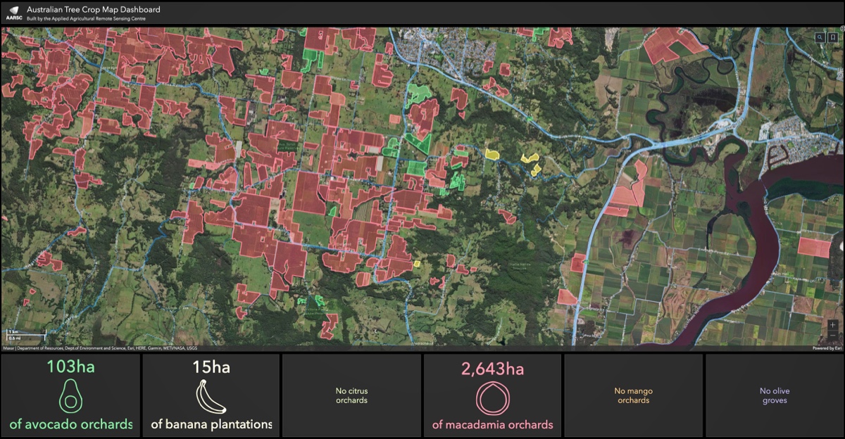
The development of a continent-wide map of macadamia orchards and improved forecasting have earned UNE's Applied Agricultural Remote Sensing Centre (AARSC) the Australian Macadamia Society's (AMS) 2021 Innovation Award.
AARSC's interactive Australian Tree Crop Dashboard is a world-first initiative that shows the location and extent of every major tree crop in the country. The product was given international prominence at this year's Esri conference.
"AARSC has really earned this award," said AMS chief executive Jolyon Burnett. "The Centre has taken some relatively old technology, satellite imagery, and devised new ways of interpreting the images to give the macadamia industry powerful new management tools."
► See the tools in action
AARSC approached the AMS seven years ago with a proposal to map the location and extent of the industry's orchards across the continent. Mr Burnett said that mapping proved to be just the first step in an ongoing and fruitful partnership between the Centre and industry.
"The mapping itself identified an additional 10,000 ha of orchards and extended our understanding of the regions where macadamias are known to be planted."
"Now we have the mapping, AARSC are calibrating their imaging tools to diagnose tree health, or to detect the early outbreak of disease, or to assess the productive capacity of an orchard."
The Centre's scientists and growers are now engaged in a partnership to use remote analysis of tree health to predict crop yield.
"The process is delivering yield predictions for most farms that within less than 15% of the actual yield," Mr Burnett said. "That makes remote sensing crop forecasts a really powerful and accurate diagnostic tool. We're excited about the opportunity to remotely predict the entire crop across all our growing regions."
AARSC director, Professor Andrew Robson, expressed his appreciation for the award, and for the warm seven-year partnership between the Centre and the macadamia industry.
"We couldn't have achieved the results we've got if it wasn't for the terrific engagement from AMS and growers, many of whom have worked hard to ground-truth our interpretations of the remote imagery."
For the industry's part, Mr Burnett said, "It's been an absolute pleasure working with AARSC. They are one of the most industry-focused research groups that we have ever engaged with us. They have maintained a proactive approach, always looking to add value to what we're trying to do."
"When we had the 2019 bushfires, very quickly - and without us even asking - AARSC overlaid maps of the fire extent with maps of our orchards, and we were able to report to government on the extent of the damage.
"Similarly, when we get east coast lows sweeping down, AARSC can quickly tell us the extent of the orchards affected, the likely percent of production and the dollar value, and we can pass that information onto government. These are really powerful tools to help us and government respond to disaster situations."
The partnership appears set to continue for the foreseeable future.
"We are now getting growers who have planted or are planning to plant macadamias who contact us, and we send them straight to the tree map dashboard and they enter their information in real-time," Mr Burnett said. "That just adds to the power of the software."
That grower-level adoption of the AARSC's work "is just gold for us," Prof. Robson said. "It means the industry is genuinely benefiting from our work. That's why we do what we do."


