Australia is consolidating its global leadership in mapping and managing horticultural tree crops with an industry collaboration worth over $9 million that will develop remote sensing applications for improved biosecurity response, pest and disease detection, yield and quality forecasting.
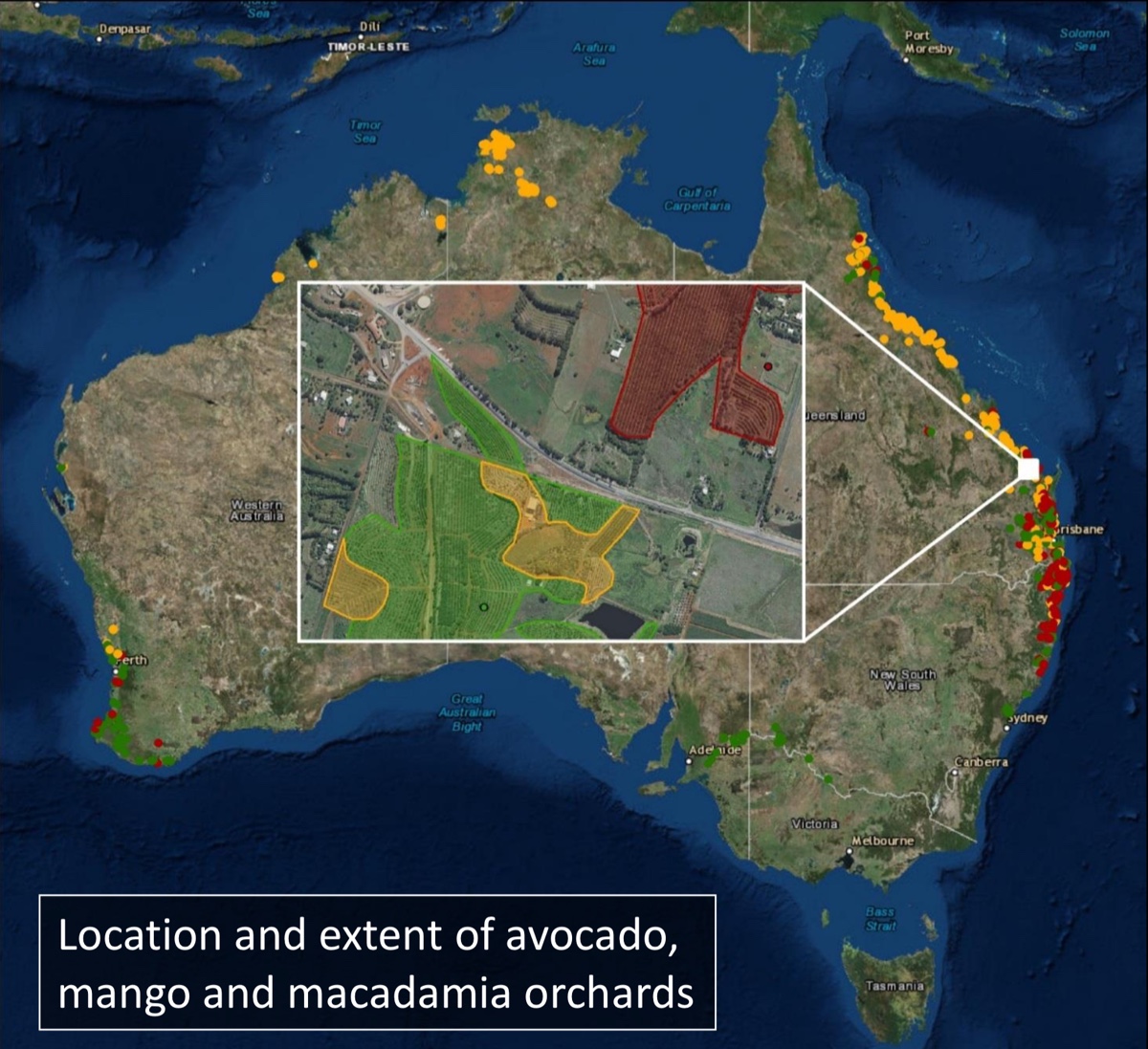
The project, led from the University of New England (UNE), is an expansion of an earlier initiative that mapped commercial avocado, mango and macadamia orchards across the country. The new phase will include the citrus and olive industries, double the minimum mapping resolution of orchards to 1 ha, and transform research knowledge into practical tools for growers and the value chain.
“We’re at the forefront of a shift that is advancing remote sensing from a sometimes crude mapping tool to something that is central to on-the-ground decision making for producers and their value chains,” said research lead Professor Andrew Robson, who also initiated the highly successful first phase of the tree crop project.
“This new phase of the project is partly about expanding our scope and refining our technologies, and partly about incorporating our knowledge into commercial tools and platforms that can be used by growers and the value chain.”
The new project, Multi-Scale Monitoring Tools for Managing Australian Tree Crops - Phase Two, has been funded by the Federal governments ‘Rural Research and Development for Profit’ scheme, Horticulture Innovation Australia (as the managing Rural Development Corporation) and participating partners.
UNE is the leading research agency working in collaboration with industry, research bodies and commercial entities - The University of Queensland, Central Queensland University, Queensland Department of Environment and Science, NT Department of Primary Industry and Resources, Queensland Department of Agriculture and Fisheries, New South Wales Dept. Primary industries, Northern Territory Farmers Federation, Australian Centre of Land Use and Management Program, Citrus Australia, Australian Banana Growers Council, Australian Mango Industry Association, Australian Olive Association, Australian Macadamia Society; Boundary Bend ltd, Costas, Tie-Up Farming, CERES imaging, Felix Instruments, Pinata Farms, Hortical and Manbullo Ltd.
Image: Professor Andrew Robson
“This collaboration includes the relevant partners and experience to effectively identify current industry need, undertake the extensive in-field calibration and validation of the latest technologies and analytics and then commercialise and extend outcomes to industry to ensure it is placed in the hands of end user,” Prof. Robson said
“This initiative really strives to bridge the growing disconnect between mass produced platforms generated through the current agritech boom and their on-ground relevance, practicality and affordability in addressing specific and current industry issues.
“Through initiatives such as this, Australia is at the forefront of developing adoptable remote sensing applications that extend from the individual tree, to the farm, state and then national level,” he said.
During the first phase of the project, the collaborative team demonstrated that remote sensing of tree crops using satellites, conventional and unmanned aircraft and ground-based sensing platforms can dramatically enhance the ability to manage tree crops and provide intelligence to the value chain.
· The project demonstrated remote sensing's ability to provide more accurate orchard yield and quality forecasting, as well as improved detection of disease, nutrition and pollination efficiencies.
· The University of Sydney demonstrated the potential of robotic platforms for counting mango fruit, whilst University of Queensland evaluated the use of drones and LiDAR.
· Prof. Kerry Walsh (Central Queensland University) developed the ‘FruitMaps’ data tool to assist mango growers in better predicting optimal maturity and therefore harvest time.
· Following the Category 4 Cyclone Debbie’s crossing of the Queensland coast in 2017, the ‘Australian Tree Crop Rapid Response Map’* produced by project partner Craig Shepherd (Queensland Department of Environment and Science) was able to provide accurate estimates of damage and loss to the avocado and mango industries. The layer also offers significant benefit in terms of biosecurity preparedness.
The Phase 2 Project aligns with the biosecurity theme and will work closely work with Australian Banana Growers Council to investigate improved surveillance methods for banana Panama disease as well with Citrus Australia for high-risk threats such as Canker and Huanglongbing (HLB).
"Collectively, these initiatives will support the ongoing future production and global competitiveness of our horticultural industries, as well as ensure new resilience against plant biosecurity threats,” Prof. Robson said.